This includes part of walk 8 in "Walks around Melbourne".
 Anchor Church - beautiful setting
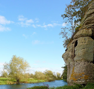
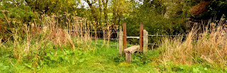
A lovely autumn day tempted me to revisit Anchor Church at Ingleby and I was not disappointed. I parked on the wide verge by the HGV entrance to Repton Prep school at Foremarke. Ignore the path opposite and head along the road to Ticknall. After a 100 metres take a path on your left which crosses a field to some metal structures by the side of the track. The path now heads straight ahead towards Anchor Church with a cliff face on your right. Over a curious metal stile and you have reached the intriguing caves which contain the Anchor Church. A steep climb up from the caves takes you to a great view of the ox-bowed Trent. Soon you spot Barrow-on-Trent church on the left bank and then the hamlet of Ingleby ahead.
Metal stile leading to Anchor Church caves
Look out for the llama farm and then follow the road (left) into Ingleby. Lots of recent building here with many barn conversions.

Ingleby hamlet with llama farm in foreground
Make sure you see the village well cut into a small cliff opposite Well cottage.

The well at Ingleby
The only problem on the walk so far was spotted in the field, on the right, leading to Ingleby Toft just short of the John Thompson (not on this walk). The farmer here usually doesn't bother to return the path after ploughing without pressure.
After refreshment in the excellent John Thompson Inn retrace your steps to the footpath that came down from the ridge above the Anchor Church. At the top of the first field take the left hand path (you came down the right hand one). This bridleway was new to me and absolutely delightful. Half way along the path you meet a series of sturdy blue metal gates. The last one is on the Ingleby to Milton road.

Looking down the “blue gates path” to the first blue gate
Less than one kilometre of road walking takes you back to the starting place. Not a true circular walk and not the best walk around here but very enjoyable nevertheless!

A lovely autumn day tempted me to revisit Anchor Church at Ingleby and I was not disappointed. I parked on the wide verge by the HGV entrance to Repton Prep school at Foremarke. Ignore the path opposite and head along the road to Ticknall. After a 100 metres take a path on your left which crosses a field to some metal structures by the side of the track. The path now heads straight ahead towards Anchor Church with a cliff face on your right. Over a curious metal stile and you have reached the intriguing caves which contain the Anchor Church. A steep climb up from the caves takes you to a great view of the ox-bowed Trent. Soon you spot Barrow-on-Trent church on the left bank and then the hamlet of Ingleby ahead.

Metal stile leading to Anchor Church caves
Look out for the llama farm and then follow the road (left) into Ingleby. Lots of recent building here with many barn conversions.

Ingleby hamlet with llama farm in foreground
Make sure you see the village well cut into a small cliff opposite Well cottage.

The well at Ingleby
The only problem on the walk so far was spotted in the field, on the right, leading to Ingleby Toft just short of the John Thompson (not on this walk). The farmer here usually doesn't bother to return the path after ploughing without pressure.
After refreshment in the excellent John Thompson Inn retrace your steps to the footpath that came down from the ridge above the Anchor Church. At the top of the first field take the left hand path (you came down the right hand one). This bridleway was new to me and absolutely delightful. Half way along the path you meet a series of sturdy blue metal gates. The last one is on the Ingleby to Milton road.

Looking down the “blue gates path” to the first blue gate
Less than one kilometre of road walking takes you back to the starting place. Not a true circular walk and not the best walk around here but very enjoyable nevertheless!


