I sent this letter to Lord Hunt of Kings Heath recently as part of the Ramblers campaign to keep access to rights of way through Forestry Commission land.
===
Dear Lord Hunt
I am a passionate walker and live in the midst of the National Forest, much of which is locally owned or managed by the Forestry Commission.
I am therefore writing in connection with the Public Bodies Bill that is currently in Committee in the
House of Lords. Whilst not all land accessed by the public must be publicly owned, it is vital that any sale of Forestry Commission land be carefully managed, with public access as a top priority.
I am very keen that community groups are able to take a more active involvement in their local woodland, but it is important that everyone’s ability to continue to access and enjoy British woodland is at the forefront of any sale agreement.
I would like you to ensure that five key criteria are included on the face of the Bill itself – to be met before any sale of Forestry Commission land is considered.
1) Public access is maintained and enhanced.
2) Public rights of way and access land are properly managed.
3) No sale or transfer is completed until the purchaser has committed to preserving and maintaining access.
4) Where access is currently not secured in law, this is remedied through CROW Act dedication.
5) The local community is consulted and given the opportunity to play a full and active part in woodland management, including first-refusal on purchase.
I would urge you to raise these concerns in debate, and ensure that the Public Bodies Bill will not damage the interests of walkers and other outdoor enthusiasts.
Best regards
Barry Thomas
Melbourne
cc:
Eva Hartson-Sanders
cc:
Baroness Royall of Blaisdon
Also look here:
38 Degrees | Save Our Forests
A blog devoted to protecting footpaths, local to Melbourne, in South Derbyshire and North West Leicestershire, England.
Thursday 9 December 2010
Sunday 28 November 2010
New Greenway Signs
Having been to a recent talk about the Greenways initiative at the South Derbyshire Environmental Forum in Swadlincote, I was pleased to see this new sign on the Cloud Trail just outside Wilson. These handsome signs are definitely an improvement on those they have replaced.
Monday 25 October 2010
A neglected area of South Derbyshire - Sutton on the Hill, Thurvaston, Osleston and Longford
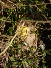
In this bush is a footpath sign. This is on Back Lane, Sutton on the Hill. This very pleasant area (about 5 miles south of Ashbourne) has some of the worst footpath problems I have encountered in the county. On a day's walk I came across ten problems that I felt had to be brought to the attention of the DCC PROW team. The sad thing is that most of the problems were here five years ago and I have the photographs to prove it.
To be fair to Longford, their paths were in better condition than the others.
More recent photos are here.
Tuesday 12 October 2010
First the Old Plough has gone and now the footpath is being moved!
This is all that's left of the Old Plough at Weston: an attractive old pub flattened to make way for a housing estate. That's bad enough but now the footpath is going to be moved from stone wall it used to follow to a pavement through the estate. It looks as if there's not much that can be done now. This is just a further degradation of our Right of Way system.
Monday 13 September 2010
Friends of Elvaston Castle 1of 3
An eye-opening video. A bit shaky in places but worth watching.
It claims that some ROWs will be lost. I'll have to contact them to check the facts out.
Monday 23 August 2010
Blissful Walk on the Leicestershire Round
It's been sometime since I have walked in High Leicestershire and yesterday was the perfect day to do it after so much dismal weather.
This is an unspoilt part of the country, moderately high for the region (600 to 700 feet) and with glorious vistas from the hill top villages. Walking is easy on the whole as route marking is very good with those friendly yellow posts. I was also lucky to find a decent pub in Somerby, the Stilton Cheese and will have to visit Grant's in Burrough on the Hill soon which has its own brewery.
Route: Thorpe Satchville (Bakers Lane) - Burrough - Somerby - Leicestershire Round through Dalby Hills - Burrough hillfort - Thorpe Satchville via Bakers Lane. About 8 miles.
Thursday 19 August 2010
Fancy Walking from the Peak District to London?
This was the request for a route to the capital from Edale on the Walkingforum this week.
So I got to thinking about this using Long Distance Footpath routes.
Here's what I wrote, though I can't see me doing it for some time!
=================================================
I live in the East Midlands so can vouch for that bit.
So you could try:
The Limestone Way (starts at Castleton - not far from Edale) to Tissington
Tissington Trail to Ashbourne
Bonnie Prince Charlie Way (Ashbourne) to west of Derby (Lees)
Derby City Nomads Circular (South) to Swarkestone
Easy footpaths from Swarkestone through Melbourne to Heath End (Staunton Harold) to pick up the Ivanhoe Way (towards Ashby).
Ivanhoe Way through to Leicestershire Round
Leicestershire Round to near Market Harborough
Link your way through to Hobblers Way
Hobblers Way to Grand Union Canal
Grand Union Canal Walk to London
Thames Path
Thames Down Link
North Downs Way to Canterbury
Obviously there are hundreds of variations of this route you could take.
You could do much of it by canal from Heanor Derbys to London but that could be boring for the whole length.
Also the Midshires Way from north of Derby goes a long way south and is quite well marked.
The Derwent Valley route goes roughly Sheffield to Derby.
Best starting websites:
http://www.ramblers.org.uk/info/paths/region/pathsregion.htm
http://www.ldwa.org.uk/ldp/public/ldp_public_home.php
Tuesday 10 August 2010
Donington path saga continues
Still no news about whether the path (L87) was legally closed during the Download Festival in mid June.
Why are Leicestershire County Council dragging their heels on this matter?
We need an answer!
Why are Leicestershire County Council dragging their heels on this matter?
We need an answer!
Friday 30 July 2010
Robin Wood Meeting
Committee members of Melbourne Civic Society and a local Ticknall resident met Alan Dowell and James Williams of the Forestry Commission at Woodside Farm to discuss the future of Robin Wood and access issues.
We were shown the recently cleared area and sections of the wood which had recovered after thinning out and the removal of conifers five years ago. The Forestry Commission, as well as removing conifers, was planting oaks and cherry trees. We were also given copies of the impressive 50 year development plan for the wood which describes how the wood will return to a mainly deciduous state (as it had been before World War Two). The habitats of raptors, owls and bats were also being protected. A tall dead tree has been left as a lookout post for raptors.
Mr Dowell assured us that access to the bridleway and footpath through the wood was protected and that they would both be better signed in the future. In all, a very positive morning's visit.
Saturday 24 July 2010
Offa's Dyke Photos
I have uploaded some photos of the first section of Offa's Dyke walk here.
http://www.flickr.com/photos/histman/sets/72157624445144569/
I am hoping to add them as a slideshow in this blog when I work out how to connect Flickr to Picasa!
http://www.flickr.com/photos/histman/sets/72157624445144569/
I am hoping to add them as a slideshow in this blog when I work out how to connect Flickr to Picasa!
Saturday 17 July 2010
Slow walk on Offa's Dyke
On unfamiliar territory this week, as I have been walking my first section of Offa's Dyke, a path I have wanted to walk for years. The weather was not great on the first day and the walking is strenuous compared with around here! However the scenery along the Wye is glorious and both Chepstow and Monmouth are towns worth spending some time in. The villages of Redbrook and Brockweir also have a great deal of charm. It took me two days to walk the 18 miles from Sedbury Cliff to Monmouth. I was pretty tired at the end of the second day!
Monday 5 July 2010
Ingleby - Lows and Highs
Route: St Brides, Robin Wood, Knowle Hill House, Seven Spouts track, Ingleby Toft Back Lane, Ingleby, John Thompson PH, Ingleby Toft, Woodend Lane, St Brides.
Today I decided to check the paths around Ingleby. After passing by the tree felling at Robin Wood (below) the bridleway which is usually very muddy was fine. In fact I hardly recognised the track! The route through to Knowle Hill House was easy to follow even when passing through crops and I managed to get a great view of the Landmark Trust property I hadn't seen before. Just beyond Knowle Hill House a stile was broken. Disappointing, as I had reported this some time back.
After crossing the lane that goes between Ingleby Toft and Seven Spouts the bridleway was again clear through crops. On reaching the Ingleby Toft to Foremark back lane I noticed a broken finger post and a missing one on the other side of the road. Instead of going straight over and down to Ingleby I decided to check a path that comes off the lane a little further west. This was a new one to me and I found it difficult to find the entrance in the hedge which was very over-grown. After hacking away at the greenery I managed to enter the field at the start of the path. There was a dead baby deer on my left, fly-ridden in the heat. The path should have been on my right. Unfortunately it was obstructed by a barbed wire fence. Another report to be made to DCC!
I went back up the lane, not wishing to tangle with the wire and non existent path, and came down to Ingleby by the bridleway. The John Thompson Inn was closed so I made my way up Ingleby FP1 which for once was actually marked through a crop. The rest of the route through Ingleby Toft, Woodend Lane and back to St Brides was luckily uneventful.
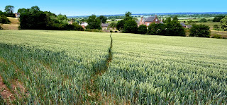
Above - Ingleby FP1 - actually navigable! A pity it's not on the DM line but you can't have everything!
Today I decided to check the paths around Ingleby. After passing by the tree felling at Robin Wood (below) the bridleway which is usually very muddy was fine. In fact I hardly recognised the track! The route through to Knowle Hill House was easy to follow even when passing through crops and I managed to get a great view of the Landmark Trust property I hadn't seen before. Just beyond Knowle Hill House a stile was broken. Disappointing, as I had reported this some time back.
After crossing the lane that goes between Ingleby Toft and Seven Spouts the bridleway was again clear through crops. On reaching the Ingleby Toft to Foremark back lane I noticed a broken finger post and a missing one on the other side of the road. Instead of going straight over and down to Ingleby I decided to check a path that comes off the lane a little further west. This was a new one to me and I found it difficult to find the entrance in the hedge which was very over-grown. After hacking away at the greenery I managed to enter the field at the start of the path. There was a dead baby deer on my left, fly-ridden in the heat. The path should have been on my right. Unfortunately it was obstructed by a barbed wire fence. Another report to be made to DCC!
I went back up the lane, not wishing to tangle with the wire and non existent path, and came down to Ingleby by the bridleway. The John Thompson Inn was closed so I made my way up Ingleby FP1 which for once was actually marked through a crop. The rest of the route through Ingleby Toft, Woodend Lane and back to St Brides was luckily uneventful.
Above - Ingleby FP1 - actually navigable! A pity it's not on the DM line but you can't have everything!
Labels:
derbyshire footpaths,
derbyshirefootpaths,
ingleby,
waymarking
Robin Wood deforestation
Lots going on at Robin Wood today.
An outfit called Euroforest seems to cutting down a large swathe of the section close to the Stanton/Ingleby bridleway. It would be nice to see the plan they are working to. I have written to the Forestry Commission for one.
Notice at entrance to the wood. The map referred to does not exist.
Logs being stacked.

Coniferous trees being logged today.
An outfit called Euroforest seems to cutting down a large swathe of the section close to the Stanton/Ingleby bridleway. It would be nice to see the plan they are working to. I have written to the Forestry Commission for one.
Notice at entrance to the wood. The map referred to does not exist.
Logs being stacked.
Coniferous trees being logged today.
Thursday 1 July 2010
Leicestershire County Council delaying tactics
Above: Castle Donington L87 blocked during the Download Festival
I am still waiting to hear from LCC about the closure of the Donington Path during the Download Festival.
I originally contacted them on 16 June. The Rights of Way Office then passed me on to their Highways Office in Mountsorrel. After hearing nothing from them I wrote to the officer concerned a week later. It has taken a week to acknowledge an email and letter sent to the officer. Today I have received a letter saying that I will have to wait up to 28 days or even longer to receive a reply.
Derbyshire gave me the information for the path on their side of the border in minutes.
Why do the wheels turn so slowly across the county border?
Monday 28 June 2010
Some great writing
With the demise of the Ramblers' Forums (see below), a fair number of contributors have gone over to the Walking Forum.
There's usually something interesting to read there not least the writing of contributor "barewirewalker".
Here's a typical example of his breathless writing that I have enjoyed recently:
Waymarking
There's usually something interesting to read there not least the writing of contributor "barewirewalker".
Here's a typical example of his breathless writing that I have enjoyed recently:
Waymarking
Tuesday 22 June 2010
A lovely day in Melbourne
A great afternoon to wander down Melbourne FP12. The perfume of camomile was in the air and the red of the poppies contrasted with the fading rape flowers. The little storage hut is sadly in a state of collapse and probably won't last long.
We are lucky to have this path open and this is mainly due to the work done by Dave Adkins the former ROW officer for South Derbyshire.
So thanks Dave and good luck!
Saturday 19 June 2010
Donington Path (continued)
The director of the Download Festival says that he has a copy of a temporary closure order for the path on the Leicestershire side. However the Leicestershire ROW officers seem to have not been informed by the county's legal team.
This order does not cover the Derbyshire side though.
This issue is important as there is a history of path closure here which was supposedly dealt with firmly by the Leicestershire Local Access Forum in 2008.
Hopefully some answers will appear next week.
See post 149 here:
http://forums.downloadfestival.co.uk/m4659848-p8.aspx
Wednesday 16 June 2010
Donington Path Closed Again - Download Festival
The Melbourne to Donington footpath has again been blocked.
I can't find any evidence yet of a temporary closure order on the Leicestershire side and Derbyshire CC have confirmed that none was applied for on their side.
The photo above was taken on Monday on the Derbyshire side which was blocked in two places, Further on, the entrance to Leicestershire was also blocked (see below).
More photos here:
http://tinyurl.com/doningtonpath
Friday 11 June 2010
Open Spaces Society
I have just been appointed Local Correspondent for South Derbyshire for the Open Spaces Society.
The society is the oldest national society involved with protecting footpaths, commons, village greens and other open spaces.
I am looking forward to working with them to protect open spaces in this area.
Their web site is http://www.oss.org.uk
The society is the oldest national society involved with protecting footpaths, commons, village greens and other open spaces.
I am looking forward to working with them to protect open spaces in this area.
Their web site is http://www.oss.org.uk
Ramblers Forums Chopped
The Ramblers have closed their forums with little notice to users or even moderators.
Their reason being that the forums were underused.
Not surprising when there was hardly any publicity spent on them and the software was looking a bit out of date.
I think some notice should have been given and some discussion on the forums encouraged about where to go next.
There were some very high quality discussions there particularly on the corruption of Definitive Map (something relevant around here.)
I have pdf-ed some of the best and placed them here for download.
http://tinyurl.com/ramforumposts
Tuesday 1 June 2010
Robin Wood Library
There's plenty of reading material up at Robin Wood these days with lots of information about current forestry activities.
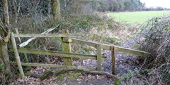
However the route marking is not good enough as the bridleway marker is on a gate post which is still on the ground (plus the maps are not very clear). There is still no news why access to the wood has been restricted.
Thursday 6 May 2010
Pool Farm Melbourne Path - Now back in
After some pressure the path at Pool Farm (Melbourne FP26) is back having been sprayed in by the farmer.
This path has not been walk-able for 8 months.
Thanks to Dave Adkins (ROW officer) for his support on this.
Above - looking towards Pool Farm.
This path has not been walk-able for 8 months.
Thanks to Dave Adkins (ROW officer) for his support on this.
Above - looking towards Pool Farm.
Wednesday 28 April 2010
A letter to all General Election candidates in South Derbyshire Part 2
Still waiting for replies from PPCs Michael Edwards and Heather Wheeler.
I have sent them another copy of the letter (see below).
I have sent them another copy of the letter (see below).
Robin Wood - Land Agents Smiths Gore Lichfield
I have written to the Land Agents who manage Robin Wood for the Church Commissioners asking them to explain why access has been restricted. The day to day management of the wood is handled by the Forestry Commission (West Midlands). I wrote to them over a week ago but no reply yet.
Saturday 24 April 2010
Pool Farm Melbourne Path - still not back in
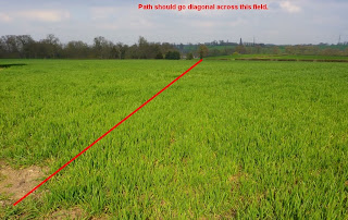
This path has been un-walkable since September 2009 when I led a walk around here for the Melbourne Festival. I have reported it three times to the County Council and am told that it will be put back in soon.
The farmer here regularly fails to do his legal duty.
Sunday 18 April 2010
Leicestershire Footpaths Association
The LFA has a very nice new website with plenty to read about the state of the nearby Leicestershire path network.
It can be found here:
http://leicestershirefootpaths.wordpress.com/
It can be found here:
http://leicestershirefootpaths.wordpress.com/
Thursday 15 April 2010
South Derbyshire Election - First reply
Thanks to the Liberal-Democrat candidate for South Derbyshire for being the first PPC to add his name to the Ramblers Manifesto.
Here's an extract from the Manifesto roll-call:
Alexis Diouf, Liberal Democrat:
"Organisations like The Ramblers have contributed greatly to the freedom most of us enjoy of exploring and enjoying our countryside. There is much Government could do to make rambling more accessible to more people and to ensure more of our countryside is accessible to us."
Wednesday 14 April 2010
A letter to all General Election candidates in South Derbyshire
Help break down the barriers to walking in South Derbyshire
I’m writing to you to ask you to sign the Ramblers General Election Manifesto for Walking. I’m very keen that my local parliamentary candidates join me and the Ramblers in breaking down the barriers to walking, which include:
•Physical barriers - we want to see the next Government protect and improve Britain's unique path network and deliver the coastal route
•Financial Barriers: we want to see the next Government link agricultural subsidies to recreation and access provision and invest in walking schemes to benefit health, wellbeing, environment, the rural economy and climate change
•Cultural barriers: we want to see the next Government position the walker at the top of the transport hierarchy and take tough action against those who put walkers’ lives at risk through reckless driving
•Legal barriers: we want to see the next Government amend legislation to require an independent review when there is an objection to orders to gate alleyways which are used by people on foot; protect and promote public access and space, and make green space accessible, safe, and well-maintained, through use of the planning process in both town and country.
South Derbyshire has a varied footpath network but too often it is poorly signed and maintained. I walk regularly in the area and rarely do I complete a walk without missing markers and /or damaged stile or gates. I always report these but action is very slow despite the valiant efforts of the local footpath officer who obviously needs more resources.
To sign up to the Ramblers General Election Manifesto please email walking.environment@ramblers.org.uk from your constituency or official email address.
Many thanks for your time.
====
I'll publish any replies I receive on this blog.
The Ramblers' Manifesto is here.
Manifesto pledges 2010
Luckily these are now easily accessible on the web and also easy to search. So I have searched through the main three manifestos (we only have three candidates here) for reference to ROWs and public access. Here's what I found:
Conservative
"We will take forward the Marine and Coastal Access Act and ensure that its conservation measures are implemented effectively." (Page 95)
I wonder what the words "take forward" mean?
Labour
"We have created two National Parks in the New Forest and South Downs, and given the public a Right to Roam our mountains, moors and heaths. We will now extend this to the whole English coastline." (Page 8:5)
A bit more promising - no dates when this might be completed, though.
Liberal-Democrat
"Increase the general right of access to the countryside, along the
lines of the model introduced by the Liberal Democrats in Scotland." (Page 81)
I like the sound of this one - does it mean a fuller Right to Roam?
Thursday 4 March 2010
Ticknall to Hartshorne Linear Walk
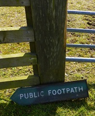
A lovely morning to walk from Ticknall to Hartshorne via Carver Rocks. The path from Ticknall, Ashby Road to the A514 was squelchy but walkable as it was under grass not a crop. After autumn ploughing, this route can be very hard work. By Scaddows Cottage I found the old Royal Label Factory sign on the ground. It must have been around here for years. Beyond this point, a plank over a brook was rather tricky as the hand rail has collapsed.
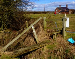
The rest of the walk was quite straightforward except for some misaligned marker discs near Scaddows Farm and an unclear route near Hartshorne Wood.
A full route description will follow soon.
Wednesday 3 March 2010
Stanton by Bridge - a new path for me!
It's a pity that nothing has been done about this signpost at the southern end of Swarkestone Bridge. It has been like this since August 2009. Look here.
I came upon this after a short stroll around the eastern part of the village. There was only one Melbourne footpath I have never walked and that one runs round the back of the Stanton Water Works down to Stanton Barn. It's a very pleasant path but the initial marking is non existent.
From Stanton Barn I walked towards the Causeway down Ward's Lane. Crossing the road I found (again) the sign above and lots of new barbed wire. Up the path, the gate across the route looks like an obstruction as I couldn't find a way to open it so had to squeeze by on the left hand side.
Reaching the Main Street I turned right then left and walked past the splendidly named The Retreat. I wanted to check the state of the stile by the side of the garden of Hills Cottage. I was glad to see a new bright yellow marker disk on the stile. I returned to the Jubilee Oak (where I had parked) along the short footpath through the wooded area behind the A514.
Sunday 28 February 2010
Swannington Path Inquiry
Swannington N28 and N108. Gates have been erected at V and X.
Location: SK413170
A landowner blocks an attractive path walked for over seventy years with an electric gate, chain-saws stiles provided by the County Council, hacks down marker posts erected by the local authority then the County solicitor argues that the path should be diverted to a new route along a muddy ditch with poor views. This is what has happened at Swannington in Leicestershire and was the subject of a public enquiry for two days this week.
When landowner Damian Spence bought his property in 2006 he knew that a public path crossed a paddock 60 feet from his small farmhouse. The stiles on the path had been maintained by the previous owners of the land for years and recently the County Council had looked after them and erected footpath markers and a signpost from the main road. However, returning home one evening he found some youngsters were playing with his animals and he determined that the path needed to be diverted. Here an error by Leicestershire County Council came to his aid.
The path walked for seventy years is not on the exact route of the Definitive Map entry. When council housing was built in 1936 at one end of the path the original route must have been diverted. Unfortunately the paperwork of Ashby Rural District Council seems to have been lost and the order cannot be found. When the Parish Survey was undertaken in 1951 (for the 1949 Act) the route marked on the map was the old route though the written description of the route makes it clear that locals were walking the diversion. The parish council had been provided with a map of 1925 which did not include the new housing and still showed the old path.
Leicestershire County Council had even worked with the local Heritage Trust producing publicity for walks on the path in the 1980s. Ordnance Survey maps have shown the route (not on the Definitive Map) since the 1960s onwards. There is a requirement of the 1949 act that the Definitive Map should be updated on a regular basis. The Council failed to do this (and has blamed the Parish Council for the mapping error).
So what does the Council propose should happen? Well, firstly they want to add the path walked since 1936 to the Definitive Map and extinguish the old route which on the map runs through gardens of two council houses built at that time. Great! But then once this route is added to the Definitive Map they want to divert it along a strip of land purchased by Mr Spence which is often waterlogged and runs by a murky ditch. Of course this takes the path well away from his house and horses, prevents the public from experiencing pleasant views towards Charnwood Forest and crossing a rare stretch of ridge and furrow for this part of Leicestershire. Given the landowner's attitude to footpaths, can we expect him to keep the diverted path in a good state?
Are we to have all paths diverted now that pass through paddocks with horses?
The case by Leicestershire County Council was shoddy. The maps produced were inaccurate and it seemed as if the ROW officer present had never been up to look at the proposed diversion route (at least he didn't seem to have much knowledge of it when we went on the site visit). Worse still was the behaviour of the County Solicitor who acted more like an advocate for the landowner.
Swannington Parish Council presented their evidence with dignity and restraint despite the fact that they were very angry about the situation which has been going on for four years. Also backing up their case was retired solicitor Dr Sheila Smith who had done mountains of research and presented her case brilliantly. Anyone involved in a footpath dispute would love to have her on their side. Representatives from the Ramblers and the Leicestershire Footpaths Association also made strong cases against the diversion.
We will now have to wait a few months for the decision of the inspector.
There is a discussion on The Ramblers forum here.
Thursday 11 February 2010
Scaring the birds and walkers?
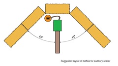
A pleasant afternoon to walk along Melbourne FP 20 to Castle Donington. However just behind Ramsley House I came across this. On investigation it became clear that it was a bird scarer on some type of timer. I have no problem with farmers using these as long as they don't go off all night by mistake! However it is not sensible putting one by the side of a Public Footpath. In fact this is totally against the advice of the NFU who strongly advise they are located away from walking routes. They should also be surrounded by baffles usually in the form of bales (image from NFU leaflet below). There should also be a warning notice before you come to the scarer.
Navigation around here can be difficult as the marker post in the hedge beyond this point is well and truly hidden. So hidden - that I only spotted it today and this is my third time down this path in three months! Hopefully this will be improved soon.
Wednesday 10 February 2010
Stanton by Bridge – West Wood
Robin Wood - some progress
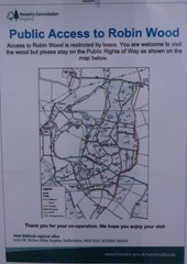
The misleading sign above has been corrected by a notice pinned to the leg of the sign showing rights of way through the wood.
Unfortunately the notice is very difficult to read (I could barely make out the routes on the map - see below) and its attachment is rather flimsy.
I wonder why the owners (the Church Commissioners) have changed the access rules to the wood as until recently it was completely open access.
Monday 1 February 2010
Weston Cliff - looking for the old ferry
Location: Weston-on-Trent, Derbyshire SK394273
Start: Weston Parish Church
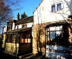
The bridge above carries the footpath from Weston Cliff over the Trent Navigation. It is a very picturesque spot. Uphill to the left is the old Cliff Inn now a Ukrainian social club. The Cliff Inn at one time was the old Manor House. Now it's looking rather scruffy with lots of old vehicles parked round the site and a large "Keep Out" sign on a nearby metal gate.The inn building (below) seems to have taken a bit of a battering with several inappropriate additions.
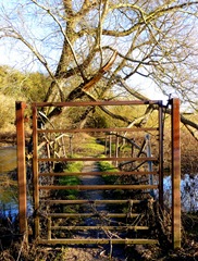
I was trying to find the site of the old Weston ferry that took people over the Trent to Kings Newton and Melbourne along Melbourne footpath 2, also known on as the Trent Meadow path. After crossing the canal bridge you come down on to the tow path. At this point look for a grooved path on your right which heads towards the River Trent. The path makes its way over a little bridge with a tall metal gate. From here a clearly defined track takes you to the river bank.The ferry reached the other bank to the left of the electricity pylon opposite, but I could find no sign of it on this side.
Walking back towards the canal I was surprised about the amount of litter here. Back on the bank I turned right and strolled towards Kings Mills. This section is usually very quiet with views of Weston Church and Hall on your left and the Wiggs, Kings Newton on your right. Pass under canal bridge 9 and about 700 metres later you come to Weston Lock. Cross the canal bridge and walk uphill towards Weston. Just after the railway bridge a path leads you through two fields to the car park of the defunct Old Plough. The grounds of the Plough are in a mess; lots of trees have been cut down/back and some of the contents of the pub have been scattered around. Looking back at the pub you realise what a big place it was. It must have been several cottages knocked into one.

From the triangular Green walk towards the Coopers pub, within a few metres an arrow on a pole points left to a path between fencing. When this opens out make your way around the lake to a spot directly opposite the Coopers. In the hedge you will find a post with two arrow markers (you might have to search for it). From here head diagonally right to the corner of this large field. When you reach the road turn left and soon you will see the track that leads back to the church.
The route in Google Maps:
Tuesday 26 January 2010
Stroll in Calke Park
A pleasant sunny afternoon after a grey morning. I decided to explore some areas of Calke I haven't been to often. The photograph above shows the restored Deer Shelter, almost unrecognisable from the mass of scaffolding here two years ago. If you walk WNW (towards Poker's Leys) from this spot you can find some areas of Calke Park that few people get into as many stick to the paths or even the main road.
Friday 22 January 2010
Recent work on the Melbourne Hall Estate
Sunday 17 January 2010
Not as it seems
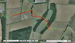
I have been playing with a new piece of online software called “Where’s the path”. It consists of two views of the same patch of land. One side can be a modern OS map (1:50000 is the most detailed at the moment) the other side can be Google maps or Google Earth or even 1930s OS maps. The beauty of this free (so far) software is that you can follow paths on one side and plot them on the other. This will make a lot more sense once you get your hands on it.
In the example above (click on the image) the yellow/green line is the route as plotted from the OS map; the red line is the actual route on the ground. This is Melbourne FP25 from the Ashby Road (opposite Sir Henry’s Lane) to Park Drive, Breedon. I had always thought that the line was wrong especially in the middle stretch now I can prove it.
I guess this is fairly typical of footpaths elsewhere and not much can be done about it whilst more urgent problems have still to be addressed.
“Where’s the path” can be found here.
Friday 15 January 2010
Winter wonderland
Sunday 10 January 2010
Not keen on walkers here?
Spotted this yesterday on Repton FP27 just beyond Common Farm, Milton (SK319265). It looks like someone has tried to obliterate the footpath markers here with green paint. This has been done both sides of the stile so is no accident. The stile is on the edge of some fairly new barn conversions. Presumably someone does not like walkers around here?
Monday 4 January 2010
Sir Henry's Lane Melbourne to Breedon and Back
A lovely crisp day to walk from Sir Henry's Lane (above) to Breedon and onto Staunton Harold and back. The lane (named after one of the Harpur Crewes) is now blocked by two large tree trunks and is only accessible for 300 metres but before the reservoir was built it crossed the valley to Derby Hills and became Broadstone Lane. Even this short stretch is still evocative of an old coach road.
Opposite Sir Henry’s Lane is Melbourne Footpath 25 which leads to the Park Drive near Breedon. The path is not clear to begin with but follow the poles and it should become clearer. You pass by a curious concrete stile on your left which is not now connected to any Right of Way. Eventually it meets the Weir to Burney Rough path (FP24), also known as the Motts Path. According to the OS map the path should go straight over but the reality is different. Turn right and by a footpath sign turn left down a well marked path towards a little wood known as Paddock Pool.
Curious concrete stile – Melbourne Common
The route through Paddock Pool is obvious and involves a little climb.
At the top you cross a track and an open stretch of land. Follow the hedge uphill keeping it on your left. The next stile is slightly to your right. The next wooded area is very small and you leave it with a nice view of Breedon Church ahead. Walk towards the church across a large field. The path is usually well trod here. At the other side of this field you meet a track running left to right coming up from Green Lane Wilson. Turn right then at the next junction follow the path to the left of the hedge. You are walking along the edge of a green belonging to Breedon Priory Golf Club. Watch out for a path on your left that drops down into a ditch. If you reach forest planting you have gone too far.
The route now is very clear into Breedon where you can stop for a drink (two pubs). However if you want to press on, about 100 metres before reaching the main Breedon Road there is a stile on your right. Take this and watch out for posts all the way to Staunton Harold. It is Leicestershire path M1 and is well named as it is pretty straightforward throughout. You basically head straight on (south west if you have a compass) following those lovely Leicestershire yellow topped posts from point to point avoiding any paths to the left or right.
Sheep at Staunton Harold – viewed from the Permissive Path
When you arrive at the entrance to Staunton Harold turn right. I suppose you could go down the drive and ignore the no entry traffic signs and pick up the path on your right. However if you walk along the main road for about 80 metres you will see a gate on the left. Squeeze around the side of it (it looks like this has been done many times before) and follow the track to meet a stile on the Permissive Path. Follow the path along the wall for about a kilometre. Don't be tempted to head downhill at any stage. Stay on the ridge. The path eventually crosses the Calke to Burney Lane road into Spring Wood.
The markers in the wood are easy to follow (thanks to John Blunt of Staunton Harold Hall) and eventually you emerge on the B587. Turn left and return to wherever you parked your car.
The markers in the wood are easy to follow (thanks to John Blunt of Staunton Harold Hall) and eventually you emerge on the B587. Turn left and return to wherever you parked your car.
Subscribe to:
Posts (Atom)


