Sunday 28 February 2010

Swannington Path Inquiry

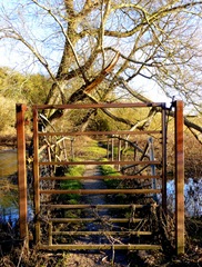
Swannington N28 and N108. Gates have been erected at V and X.
Location: SK413170

A landowner blocks an attractive path walked for over seventy years with an electric gate, chain-saws stiles provided by the County Council, hacks down marker posts erected by the local authority then the County solicitor argues that the path should be diverted to a new route along a muddy ditch with poor views. This is what has happened at Swannington in Leicestershire and was the subject of a public enquiry for two days this week.

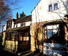
When landowner Damian Spence bought his property in 2006 he knew that a public path crossed a paddock 60 feet from his small farmhouse. The stiles on the path had been maintained by the previous owners of the land for years and recently the County Council had looked after them and erected footpath markers and a signpost from the main road. However, returning home one evening he found some youngsters were playing with his animals and he determined that the path needed to be diverted. Here an error by Leicestershire County Council came to his aid.

The path walked for seventy years is not on the exact route of the Definitive Map entry. When council housing was built in 1936 at one end of the path the original route must have been diverted. Unfortunately the paperwork of Ashby Rural District Council seems to have been lost and the order cannot be found. When the Parish Survey was undertaken in 1951 (for the 1949 Act) the route marked on the map was the old route though the written description of the route makes it clear that locals were walking the diversion. The parish council had been provided with a map of 1925 which did not include the new housing and still showed the old path.

Leicestershire County Council had even worked with the local Heritage Trust producing publicity for walks on the path in the 1980s. Ordnance Survey maps have shown the route (not on the Definitive Map) since the 1960s onwards. There is a requirement of the 1949 act that the Definitive Map should be updated on a regular basis. The Council failed to do this (and has blamed the Parish Council for the mapping error).

So what does the Council propose should happen? Well, firstly they want to add the path walked since 1936 to the Definitive Map and extinguish the old route which on the map runs through gardens of two council houses built at that time. Great! But then once this route is added to the Definitive Map they want to divert it along a strip of land purchased by Mr Spence which is often waterlogged and runs by a murky ditch. Of course this takes the path well away from his house and horses, prevents the public from experiencing pleasant views towards Charnwood Forest and crossing a rare stretch of ridge and furrow for this part of Leicestershire. Given the landowner's attitude to footpaths, can we expect him to keep the diverted path in a good state?

Are we to have all paths diverted now that pass through paddocks with horses?

The case by Leicestershire County Council was shoddy. The maps produced were inaccurate and it seemed as if the ROW officer present had never been up to look at the proposed diversion route (at least he didn't seem to have much knowledge of it when we went on the site visit). Worse still was the behaviour of the County Solicitor who acted more like an advocate for the landowner.

Swannington Parish Council presented their evidence with dignity and restraint despite the fact that they were very angry about the situation which has been going on for four years. Also backing up their case was retired solicitor Dr Sheila Smith who had done mountains of research and presented her case brilliantly. Anyone involved in a footpath dispute would love to have her on their side. Representatives from the Ramblers and the Leicestershire Footpaths Association also made strong cases against the diversion.

We will now have to wait a few months for the decision of the inspector.

There is a discussion on The Ramblers forum here.

Thursday 11 February 2010

Scaring the birds and walkers?


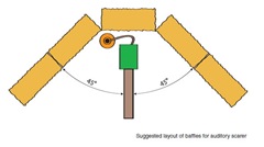
A pleasant afternoon to walk along Melbourne FP 20 to Castle Donington. However just behind Ramsley House I came across this. On investigation it became clear that it was a bird scarer on some type of timer. I have no problem with farmers using these as long as they don't go off all night by mistake! However it is not sensible putting one by the side of a Public Footpath. In fact this is totally against the advice of the NFU who strongly advise they are located away from walking routes. They should also be surrounded by baffles usually in the form of bales (image from NFU leaflet below). There should also be a warning notice before you come to the scarer.

bird scarer

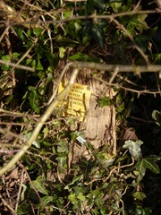
Navigation around here can be difficult as the marker post in the hedge beyond this point is well and truly hidden. So hidden - that I only spotted it today and this is my third time down this path in three months! Hopefully this will be improved soon.
P1010874


Wednesday 10 February 2010

Stanton by Bridge – West Wood

P1010868
Location: SK362260
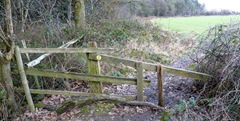
This very strange structure was once a stile – now it’s a barrier on Stanton FP 1. The owner needs to do some reconstruction work on it.

The problem has been reported to the South Derbyshire Footpath Officer.

Robin Wood - some progress

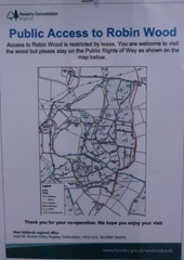
The misleading sign above has been corrected by a notice pinned to the leg of the sign showing rights of way through the wood.

Unfortunately the notice is very difficult to read (I could barely make out the routes on the map - see below) and its attachment is rather flimsy.

Robin Wood map

I wonder why the owners (the Church Commissioners) have changed the access rules to the wood as until recently it was completely open access.


Monday 1 February 2010

Weston Cliff - looking for the old ferry

 
Location: Weston-on-Trent, Derbyshire SK394273
Start: Weston Parish Church

The bridge above carries the footpath from Weston Cliff over the Trent Navigation. It is a very picturesque spot. Uphill to the left is the old Cliff Inn now a Ukrainian social club. The Cliff Inn at one time was the old Manor House. Now it's looking rather scruffy with lots of old vehicles parked round the site and a large "Keep Out" sign on a nearby metal gate.The inn building (below) seems to have taken a bit of a battering with several inappropriate additions.

weston cliff inn

I was trying to find the site of the old Weston ferry that took people over the Trent to Kings Newton and Melbourne along Melbourne footpath 2, also known on as the Trent Meadow path. After crossing the canal bridge you come down on to the tow path. At this point look for a grooved path on your right which heads towards the River Trent. The path makes its way over a little bridge with a tall metal gate. From here a clearly defined track takes you to the river bank.The ferry reached the other bank to the left of the electricity pylon opposite, but I could find no sign of it on this side.

weston trent meadow bridge

Walking back towards the canal I was surprised about the amount of litter here. Back on the bank I turned right and strolled towards Kings Mills. This section is usually very quiet with views of Weston Church and Hall on your left and the Wiggs, Kings Newton on your right. Pass under canal bridge 9 and about 700 metres later you come to Weston Lock. Cross the canal bridge and walk uphill towards Weston. Just after the railway bridge a path leads you through two fields to the car park of the defunct Old Plough. The grounds of the Plough are in a mess; lots of trees have been cut down/back and some of the contents of the pub have been scattered around. Looking back at the pub you realise what a big place it was. It must have been several cottages knocked into one.

The Old Plough Weston-on-Trent

From the triangular Green walk towards the Coopers pub, within a few metres an arrow on a pole points left to a path between fencing. When this opens out make your way around the lake to a spot directly opposite the Coopers. In the hedge you will find a post with two arrow markers (you might have to search for it). From here head diagonally right to the corner of this large field. When you reach the road turn left and soon you will see the track that leads back to the church.

The route in Google Maps:

Route around Weston Village